|
|

|

|
|
Explore
the Shaker Swamp with local filmmaker Ted Timreck.
Buy DVDs
|
|
|
|
|
|
|
|
|
|
 |
|
| |
Maps
- Habitat
Surveys - Species Lists
|
•
Aerial Photo Maps of the Shaker
Swamp
|
|
|
Click
to enlarge - will open in new windows
for comparison
|
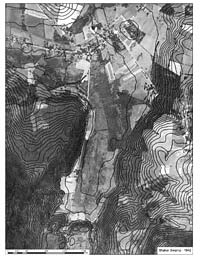
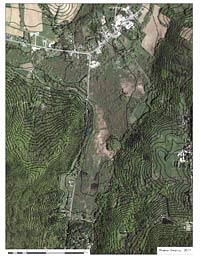
Contour
lines delineate the Shaker Swamp in New Lebanon,
NY, at the base of Mount Lebanon. Comparison
of the 1942 and 2011 aerial photographs shows
the landscape changes since the Shakers managed
the land, and is part of the research into on
the wetland significance of the Swamp.
|
| |
 |
|
•
New
Lebanon Habitat Survey (2010)
by
New York State Department of Environmental Conservation
Hudson River Estuary Program, Biodiversity Outreach
for
Town of New Lebanon Planning Board
Summary
was completed upon request to provide information
for the Town of New Lebanon for use in land
use planning and decision-making.
Describes
major natural features, important habitats of
the Town of New Lebanon, known significant birds,
reptiles and amphibians of the Town of New Lebanon
- with maps and species lists.
Included
are general conservation measures for protecting
natural areas and wildlife, links to biodiversity
databases and further research.
|
| |
|
|
•
Mt.
Lebanon Shaker Society
Shaker Museum & Library Survey Map
(2010)
by
Clark Engineering & Surveying, P. C.
Map
includes Historic Shaker District and Shaker
Swamp
|
|
|
|
|